A first-in unit rolls up to a campus they barely know. Radios crackle. Adrenaline is high. Everyone is trying to see the same problem at the same time.
Then someone hands the team a rolled-up set of architectural blueprints pulled from a cabinet. They are dense, technical, and cluttered with structural notes meant for a construction crew, not a crisis team. On paper, that search can take 20 to 30 seconds too long.
In school safety, we call this the “Interior Response Interval.” As defined by Olatunji et al. (2026), this is the critical duration between a responder’s arrival at the entrance and their arrival at the precise room of the incident. Research by Clarke & Dolejs (2021) confirms that for trauma victims, each minute of delay in treatment reduces survival probability by 7–10%.
Clarity is speed. And speed is safety.
1. The Cognitive Science of Wayfinding Under Duress
We often talk about the "fog of war," but findings from Patel and Nguyen (2020) indicate that responders in high-stress environments experience a 42% decrease in working memory capacity and a 35% decline in spatial reasoning.
This cognitive collapse is worsened by "Attentional Narrowing." Research by Williams et al. (2021) demonstrates that under perceived threat, a responder’s visual scan area decreases by 71%. In this state, a responder literally "stops seeing" the environment—room numbers and wall-mounted fire escape maps are filtered out by a brain focused exclusively on threat detection.
2. The Enemy: "Ghost" Renovations and "Building Patina"
Schools undergo constant modifications—new portables, repurposed classrooms, and moved security gates. This creates what researchers call “Building Patina”—the layer of changes that occur over decades (Johnson & Lee, 2022).
Paper maps and old CAD drawings freeze a campus in time. In an emergency, these "ghost" changes become lethal failure points:
- The Missing Door: Responders stage at an entrance that is now permanently locked or badge-only.
- The Wrong Route: A corridor shown as open is now blocked by a new security partition.
- The Shared Operational Picture (COP): The DOJ’s 2024 report on the Uvalde shooting illustrated how a lack of shared, accurate mapping led to a fragmented response where no one knew precisely where victims were located or who was in command.
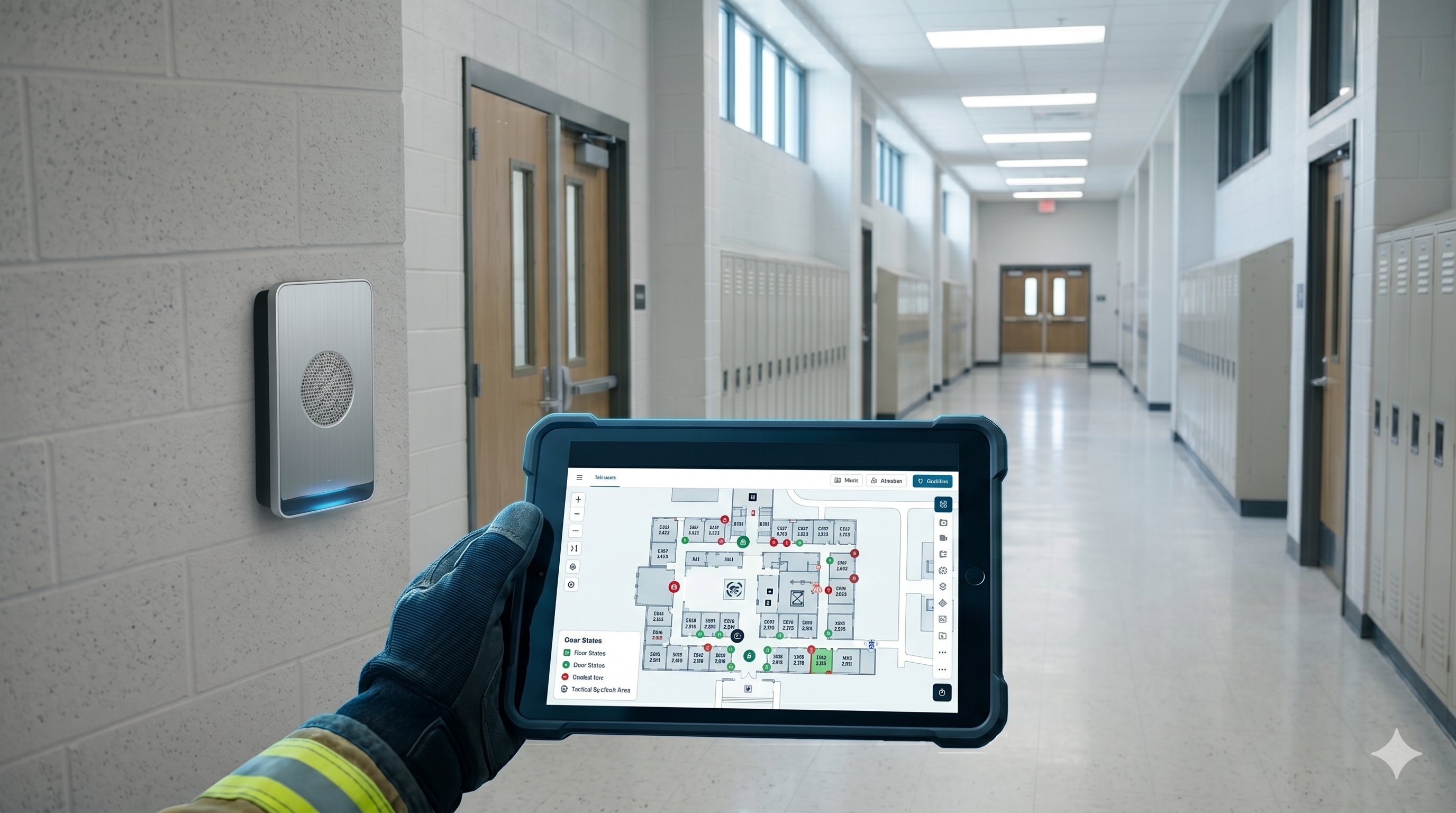
3. Beyond the Binder: Verkada's Integrated Lockdown Solution
To solve the "Science of Seconds," schools must move away from the three-ring "crisis binder" (which an IAFC survey found is insufficient for room-level navigation in 88% of departments).
As a Verkada system integrator, NIC Partners helps districts implement a "Shared Visual Truth" using Verkada Lockdown Solutions, which replaces static PDFs with dynamic, actionable floor plans:
- One-Tap Activation: During a crisis, there is no time to navigate complex menus. Verkada allows admins to initiate a campus-wide lockdown from any device with a single tap.
- Real-Time Visibility: Command-wide floor plans allow you to see the live status of every door. You can instantly identify which areas are secure and where potential breaches exist, integrated directly with live camera feeds.
- Instant Emergency Sharing: When seconds count, you can share live floor plans and camera feeds with first responders via SMS or email. This gives arriving officers the "eyes on" they need before they even enter the building.
4. The Path to "Defensible Readiness"
The transition to digital mapping isn't just a tech upgrade; it’s a policy mandate. California’s AB 598 (2025-2026) provides a legislative blueprint through the "School Mapping Data Grant Program," emphasizing that standardized mapping data is now essential infrastructure.
To ensure long-term accountability, we suggest following the standards set by the Wakulla County Performance Audit (2022):
- Audit Building Patina: Maintain a rotating schedule for map updates to eliminate "ghost" renovations.
- Performance Evaluation: Use data-driven metrics to evaluate how quickly responders can navigate the campus.
- Governance: Ensure safety performance is tracked and reported to the board annually.
Conclusions: Seconds Count, and So Does Confidence
In an emergency, responders do not need more information. They need the right information, in a format their brains can process under pressure. Implementation of Detailed Indoor Mapping is projected to reduce response intervals by 30–50% (Olatunji et al., 2026).
Paper maps and old blueprints force interpretation. Digital, integrated floor plans supported by Verkada’s lockdown platform support action.
Clarity is speed. And speed is safety.
Next Step: Evaluate Your Readiness
Mapping is a safety asset that needs governance. NIC Partners can help you evaluate your current mapping performance and explore how Verkada’s integrated lockdown and floor plan solutions can bridge the gap when seconds count.
